Twelve Days in the Himalaya

SHAKEN BUT SAFE, our terrifying touchdown in Lukla actually went as well as we could have hoped for. About a 15-minute walk from town, a stupa honoring dozens who lost their lives on earlier flights gave me a pain in the pit of my stomach. A quick reassessment of our physical state allowed me to brush it off and move on.
It was time to get lost (hopefully only figuratively) in the tallest mountain range in the world.
The Himalaya include ten of the world’s fourteen 26,000+ foot (8,000 m) peaks, including Mt. Everest at 29,029 feet (8,848 m), and they span five countries; Pakistan, India, China/Tibet, Bhutan, and Nepal. Our trek was to take between 9 and 14 days, depending on quite a few variables

Porter with a load of wood. His clothing shows he’s relatively low in the mountain range, and he is careful to keep his right shoulder to the sacred mani stone, which are always circumvented clockwise.
Day 1: Lukla to Benkar (8,923 ft. / 2,720 m)
After a look around Lukla, our first stop was at a restaurant of sorts, lined in gleaming wood panels and big bright windows. The precious provisions were sold singly, and we stocked up on Snickers, the most compact, delicious, ubiquitous energy source on planet Earth. Don’t even get me started on the gift that was Orange Fanta, even though I never touch the stuff at home.
Naturally, the higher the climb, the higher the prices. The effort expelled to transport goods from village to village became more obvious as the prices rose. All goods were flown in through Lukla, then lugged up the mountains by porters and yaks.
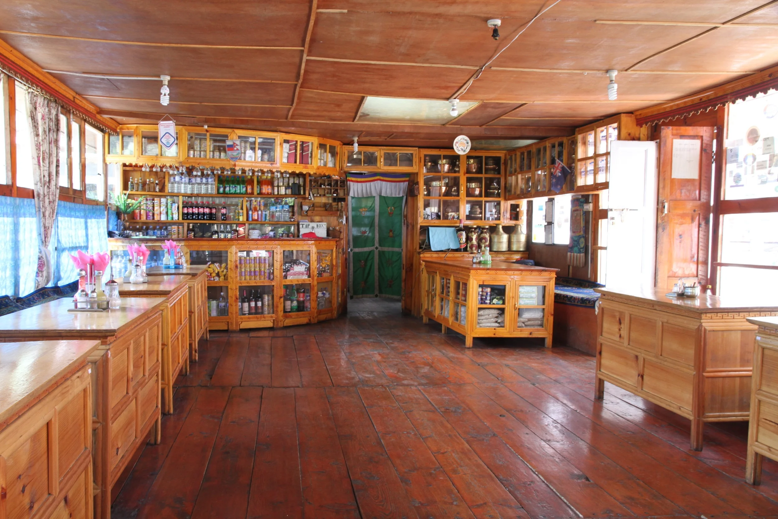
The proprietor of this restaurant/supermarket clearly takes pride in their place.
Rounding out day one in Benkar, a quiet mountain village, we cleaned up in an outhouse while the sun set behind the high mountain pass. Chickens scattered under foot, and we made our way inside to wind down for the evening.
A shared space/dining room was centered around a large wood-burning stove (the higher we climbed, the more the wood turned to yak dung - a more readily-available source of fuel). Dinner and hot Tibetan tea with butter and salt was served in a group setting, with each individual scooting closer and closer to the stove as the night dragged on.
That first evening we crashed hard, exhausted from the flight, the lack of oxygen, and the 8.5 km hike between towns. Waking up the next morning in our treehouse-like room (two single beds, light wood panels, colorful flannel blankets, and nothing more) we thought the home was on fire as smoke rose through the thick cracks in the floor. After further inspection we discovered the home owners had just started breakfast, and the kitchen was directly below our room.
We took tea on the porch, overlooking the few other buildings in Benkar, and fought with an ambitious crow, it’s great black wings beating too close to my face for comfort.

Tibetan tea in Benkar, Nepal. Not pictured is the angry crow I just fought and won.
Days 2 through 3: Namche Bazaar (11,286 ft. / 3,439 m)
Dodging yak traffic, and putting more and more effort into every breath, we made our way to Namche Bazaar, but not before getting lost. An unexpected crossroads threw us off the trail, and we bet our safety on a small dog, following his wagging tail to the next town.
Namche Bazaar is the final semblance of civilization between Kathmandu and Mt. Everest. Anyone hoping to reach the roof of the world spends time in Namche acclimatizing, stocking up on supplies, calling home, and socializing with other explorers. The town is built along the side of a sloping hill, and its colorful rooftops are stacked like Legos.

Hiking to the rim of town and back to acclimatize before the serious altitude starts.
Here we stayed at the Khumbu Lodge, the oldest family-run hotel in town. Hot showers (our last of the trek), nak cheese pizzas, and a tiny theater across the cobblestone street showing the Breshears IMAX movie on the Himalaya made this a cozy home away from home.
Quick hikes up to the edge of town and back gave our lungs a lesson in altitude, and our eyes a view of Thamserku, a 21,729 foot (6,623 m) monster who watches over Namche. Things are beginning to get seriously big up here.

Stupas and prayer flags were scattered all over the mountains.
Day 4: Namche Bazaar to Phortse Tenga (12,073 ft. / 3,680 m)
Veering left at a significant crossroads just outside of Namche Bazaar, we scratched Everest Base Camp off of our itinerary. We had decided to head for Gokyo Ri for what we had heard touted as the best views in the Himalaya. We had opted for less foot traffic, but had not given up on our chance to see Everest - which is more regularly visible from our chosen destination.
Hot spots in my boots were becoming more apparent, but it was nothing a tape job couldn’t fix. A break to pop some blisters, tape some sensitive spots, and gobble some gummy bears, and we were back on the trail.
Phortse Tenga was a sleepy village basically void of activity or noise during our stay, and that was fine by us.

On the trail to Gokyo Ri.
Day 5: Portse Tenga to Dole (13,779 ft. / 4,200 m)
Dole - home of the most uncomfortable shower I’ve ever taken.
Not yet fully embracing the mountain lifestyle, I was still interested in (though not receiving) a shower a day. The dry air and colder temperatures kept our body funk at a minimum, but if a way to wash was offered, I was taking it. The owner of our teahouse in Dole answered my request with a kind smile and an enthusiastic nod. She walked me out front to a closet-sized building with a corrugated metal roof and door and motioned for me to climb in.
Once inside I peeled off the layers I was still wearing and waited. As I stood naked and shivering, the aggressive mountain winds beat the scrubby growth, and whistled through the gaps in the rickety structure.
Just as I began to consider this whole thing a funny misunderstanding I heard pained grunts and struggling footsteps coming from outside, then the creak of a ladder and more grunting. The woman was standing above me, hoisting a large plastic vat of water and pouring it into a funnel-like contraption just over my head.
The effort and energy that went into that shower made me feel like a pampered fool. The woman had lit a fire, warmed the water (kind of), lugged it from around the house, hoisted it on her head and poured it down onto mine. I learned a lesson in convenience that day that I don’t think I’ll ever forget.
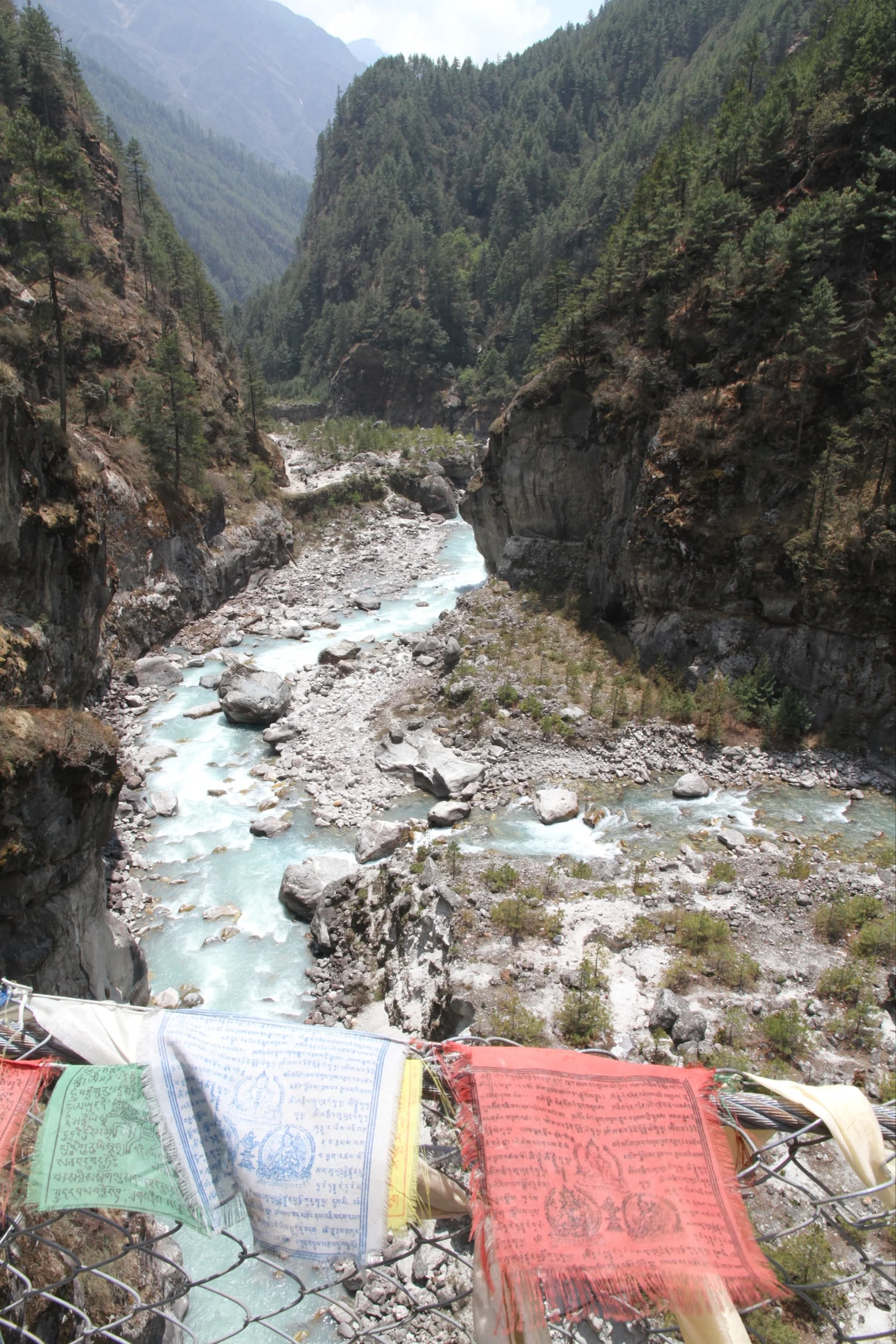
Straddling the Dudh Koshi on a suspension bridge strewn with prayer flags.
Day 6: Dole to Machhermo (14,763 ft. / 4,500 m)
It was about day six when the altitude hit me…HARD. I had taken Aspirin and drank a ton of water, but nothing was bringing relief to my pounding head. Once I saw black spots in my field of vision I knew I needed to call it. We would spend one more day in Macchermo to see if the pain would go away.

Still hanging around Machhermo, waiting for my altitude sickness to subside.
Day 7: Machhermo
Relaxing, hydrating, exploring the village and getting to know the white fluff ball who ran the place, we got absorbed in yeti lore. As the story goes, the village of Machhermo was the site of a gruesome yeti attack in the 1970s. The half-man, half-bear(?) beast that walks upright and makes a terrible whistling sound was known for slaughtering livestock in the area.
Our room had a tiny high window that looked out at giants of the Himalayan range. The wind gusts were so forceful that creaks and pops were heard throughout the night, and while I definitely knew better, my aching mind drifted to “what-if” scenarios involving yetis, only to be extinguished by real worries like avalanches, landslides, and high altitude cerebral edema. Nights at altitude can do a real number on your sense of safety…

Tashi - the closest thing to a Yeti we saw while in Macchermo.
Days 8 through 9: Machhermo to Gokyo Ri (17,575 ft. / 5,357 m)
Finally feeling strong enough to carry on, we made our way to Gokyo, the seventh and final village of our journey. We had kept the Dudh Koshi to our right shoulder (east) for the majority of the trek, but now it was time to part ways, as the first of the six Sacred Lakes of Gokyo took over as our guide.

Building a cairn next to Taujan Pokhari, aka, Gokyo II of the six Sacred Lakes of Gokyo.
The Sacred Lakes of Gokyo are the world’s highest freshwater lakes, at 16,400 ft (5,000 m) above sea level. These lakes hold permanent fresh water from various sources, including the Ngozumpa Glacier.
The village of Gokyo is nestled alongside Dudh Pokhari, or Gokyo Lake, the second largest of the sacred bodies. To get to the trailhead for taking on Gokyo Ri, hikers must skip across a shallow portion of the lake. During our visit a shining sun had melted nearly all of the ice from the ever-changing walkway of stones, and we hopped across with zero incidents.

Mani stones at Dudh Pokhari. The trailhead to Gokyo Ri, and the final ascent of our trek begins here.
As with any major ascent, I focused on simply putting one foot in front of the other. The final destination remained a vague thought, right now in the thinning air, every step was an accomplishment. At sea level there is 55% more oxygen than we were breathing in Gokyo.
Breaking often to soak in the unbelievable beauty surrounding us, we glanced down at the village we had left about an hour before, and a tiny replica lay below near a sparkling turquoise Dudh Pokhari. I struggled to breathe, but that didn’t stop me from smiling like someone who had just fallen in love for the first time.
Reaching the summit after 2km of switchbacks, Fernando and I shared a celebratory kiss and Snickers, not a bite-size bar, the full adult-sized treat. With all the obstacles overcome and energy expelled over the past nine days, we deserved it. No baby candy bars for us - not this time.

Posing with some Himalayan giants, the moraine of the Ngozumpa Glacier, the village of Gokyo, Dudh Pokhari, and a celebratory Snickers at the summit of Gokyo Ri (17,575 ft).

Fer excited about a Basque flag he found among the prayer flags at the summit of Gokyo Ri. Mt. Gyachung Kang (26,089 ft / 7,952 m) in the distance. His mother’s side hails from the Basque region in Europe.
Visible from our perch was an expansive vista of the Himalayan range, including the popular heavyweights Cho Oyu, Everest, Lhotse and Makalu, plus the glacial moraine of the Ngozumpa Glacier. Looking out, the mountains seemed to go on forever. Looking down, the bright shining lakes of Gokyo reflected the sun’s light in such a way that you had to shield your eyes.

Our final destination in the Himalaya, and my (current) apex of 17,575 feet. Mt. Everest is just off to the right - the highest dark peak. Everest is another 11,000+ feet higher than where we stand in this picture.
Watching the afternoon clouds roll over Mt. Everest in the distance, we witnessed first-hand the importance of an early climb. Had we waited even one hour to begin our ascent, we would have missed our chance to see the record-breaking peak, and nine days is an awful long time to walk to not see Mt. Everest.
The Everest climbing season of 2012 had the highest fatality total since 1996, the year of the tragic climb that inspired John Krakauer’s Into Thin Air. In 2012, 683 climbers from 34 countries made the attempt - 547 summited, and 11 died. Gazing at that monstrous mountain in the distance, with my brain depleted of oxygen, I felt the pull. I wanted to stand at the top of the world.

The worl'd’s tallest at 29,029 feet (8,848 m), Mt. Everest (Sagarmatha, Chomolungma, Goddess Mother of the World) being obscured by afternoon clouds.
Days 10 through 11: Back in Namche Bazaar
Our summit day ended back in Machhermo for another night with Tashi before the long trek to Namche Bazaar where we took too-hot showers. To-date no shower has ever felt that good. We emailed our parents letting them know of our safe descent, and splurged on yak cheese pizza and beers.
This time we walked through Namche Bazaar with a little swagger to our step. We felt accomplished - like we were in on a secret. The additional oxygen in the air at just over 11,000 feet was intoxicating. I was strong, clear headed and full of energy, despite the punishment I had just put my body through.
News from the mountains finally hit us while sitting at the Internet cafe. Four people died on Everest while we were in the Himalaya, including Canadian climber Shriya Shah-Khlorfine who was trying to complete her very first mountain climb…ever…and she chose Everest…and was actually allowed to go.
Maybe it was this dire report, or maybe it was just the higher level of oxygen in my brain, but I decided right then that less deadly peaks would do just fine, and scratched Everest off my list.

One must constantly be on the lookout for yak trains on the trail. These three are taking a break from work.
Day 12: Back in Lukla
Our last night in the Himalaya was spent back where we started in Lukla. I could no longer suppress my thoughts and fears about the flight out - it was time. We had survived twelve days in the world’s highest mountain range, but our final test lay ahead.
Neighborhood kids had gathered again, this time to watch our take-off. The winds were calm, the sky was clear, all signs pointed to a flawless flight. We tossed our bags in back and climbed into the craft. I buckled my seatbelt, a vestige of security, like it would actually make any difference.
The engines raged and the propellers sputtered to life. Swiftly, we turned the hard right angle and the pilot aimed the planes nose directly at the cliff edge. With nary a moment to catch my breath, we were barreling down on the drop. My heart pounded so hard I could hear it in my head as we neared the point-of-no-return. I wanted to close my eyes but I couldn’t. Thoughts at a million miles an hour as my mind reeled with anxiety, the runway disappeared and the earth dropped out from below. My stomach leapt into my throat as the plane caught a gust of wind and lifted us up to safety.
———-
VERDICT: Mostly Harmless - but often pretty dangerous. Proceed with caution!
—|||—
Khumbu Lodge: Hotel and restaurant in Namche Bazaar, Nepal. Popular lodge for Himalayan trekkers.
Into Thin Air: John Krakauer’s best-seller and personal account of the Mt. Everest disaster in May of 1996.
High Altitude Cerebral Edema: (HACE) may occur in up to 3% of trekkers at altitudes of 15,000 ft or higher. Symptoms are severe headache, confusion, drowsiness, stupor, and in extreme cases, coma.

Herder’s hut abandoned for the season.


